New Issues and stamp news 851
Cocos (Keeling) Islands – Waterhens
Issue date: September 19, 2023
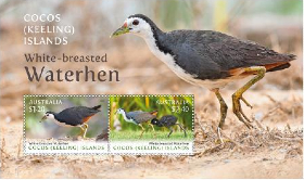
The White-breasted Waterhen is a waterbird from the Rallidae family, around 30 centimetres in length, with a distribution from the Indian subcontinent east through southern China, and most of South-East Asia. The nominate subspecies (Amauronrnis p. phoenicurus) can be found on the Cocos (Keeling) Islands and Christmas Island. First recorded in the 1990s, the White-breasted Waterhen is now plentiful on the Cocos (Keeling) Islands, where it also breeds. A timid water bird 24-28 centimetres in length, its upper parts are dark slate-brown with a white face and breast, and deep red eyes. It has chestnut flanks and undertail coverts. The bill is green or yellow, red at the base, and the legs are yellowish green. The bird has large feet and flies with its legs dangling.
Jersey – Emergency Services
Issue date: April 1, 2023
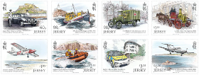

A set of eight stamps from our ‘A History of Jersey’s Emergency Services’ issue. Stamp engraver Martin Mörck illustrates Jersey’s emergency service vehicles across the last century. All our mint/cto products are carefully prepared by our own team and supplied in glassine bags to ensure you receive them in pristine condition. Selvedges are retained where possible.
Gibraltar – Europa 2023 PEACE
Issue date: March 30, 2023


EUROPA stamps are special stamps issued by European postal administrations. They bear the official EUROPA logo, a PostEurop registered trademark under the aegis of PostEurop in which Europe is the central theme. EUROPA stamp issues are among the most collected and most popular stamps in the world and have been issued for over 60 years. Every year a new theme is assigned by PostEurop and all participating countries issue stamps with their own interpretation of the theme. The theme for 2023 is ‘Peace – the highest value of humanity.’
Peace is a concept of societal friendship and harmony in the absence of hostility and violence. In a social sense, peace is commonly used to mean a lack of conflict (such as war) and freedom from fear of violence between individuals or groups.Throughout history, leaders have used peacemaking and diplomacy to establish a type of behavioral restraint that has resulted in the establishment of regional peace or economic growth through various forms of agreements or peace treaties. Such behavioral restraint has often resulted in the reduced conflict, greater economic interactivity, and consequently substantial prosperity.
Australia – Centenary of Legacy
Issue date: March 21, 2023
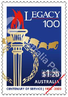
This stamp issue commemorates the centenary of Legacy in Australia. This national charitable organisation was established in 1923 in Melbourne to provide services to the families of Australian Defence Force veterans killed or wounded in World War I. In 1923, returned serviceman Major General Sir John Gellibrand formed the Remembrance Club in Hobart to aid those who suffered because of war. Another returning soldier, Lieutenant General Sir Stanley Savige, was inspired to establish a similar club in Melbourne, which was named Legacy.
Legacy is still caring for tens of thousands of partners and families who have lost their loved ones or have been adversely impacted by conflicts across the globe, including the Korean War, Malayan Emergency, Vietnam War, campaigns in Iraq and Afghanistan and in peacekeeping operations. Today, there are 44 Legacy Clubs throughout Australia and one in London, providing emotional, social and financial support. Legacy currently supports 43,000 individuals and families across Australia, supported by over 3,600 volunteer members or Legatees. Funds to support Legacy’s work are raised by a variety of methods, the most notable being the sale of special badges and other goods during Legacy Week, which is usually during the first week of September.
$1.20 100 Years: Legacy Australia The stamp design presents the iconic branding of Legacy Australia and echoes the colours of the Australian flag. The torch design prominently placed in the stamp represents the undying flame of service and sacrifice, the foundation of Legacy’s existence. The body of the torch is presented in a gold colour, signifying generosity and compassion. In its wreath of laurel, with its points inverted in remembrance, is the guerdon of honour, to represent those who gave their lives for their country.
Jersey – Traditional Markets
Issue date: March 21, 2023
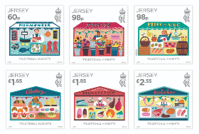
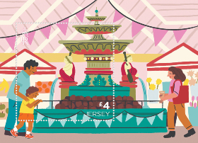
Jersey’s traditional markets are the subject of a set of stamps and a miniature sheet to be issued by Jersey Post on 21 March 2023. Jersey illustrator Lauren Radley has brought to life representations of six of the traditional stalls found in Jersey’s Central and Beresford Street markets, perfectly capturing the lively atmosphere and range of colourful, local produce.
Jersey’s Central Market and Beresford Street Market are found just a short walk from each other in the town of St. Helier and have been home to Island vendors since the 1800s. Jersey’s Central Market is an outstanding example of a Victorian open market and was built as part of the States of Jersey’s Battle of Jersey centenary celebration. Construction started in 1881 and took two years to complete. The Beresford Street Market is located opposite Jersey’s Central Market and is better known as ‘The Fish Market’. Covering around 10,000 square feet, the market was built in 1841 and restored in 1873, 1936 and again in 1972.
Featured across the six stamps are a fishmonger, a florist, a fruit & veg stall, a bakery, a delicatessen and a butcher. The 98p ‘Fruit & Veg’ stall stamp carries the logo of SEPAC, the Small European Postal Administration Cooperations, and forms part of a joint stamp issue, also entitled ‘Traditional Markets’. The miniature sheet features the iconic cherub-clad fountain which is the focal point of the Central Market.
Stamp artist Lauren Radley says of the project: ‘I loved working on this set of stamps; the Central Market is such a colourful, vibrant place and I have always wanted to create some work around it, so when I was asked to illustrate these stamps I was so pleased to be able to finally have the opportunity to produce something! I loved the ‘research’ part of this project; spending time in the markets, chatting to the different stall holders, and taking photographs of them and their produce. I really wanted to capture the personality and diversity, not only of the produce on sale, but of the characters working, and shopping there too, and I hope that this collection conveys the fun and bustling atmosphere of our markets.’
Jersey based artist Lauren Radley graduated from Kingston university in 2009 with a BA (Hons) in Illustration and Animation. Having worked as a freelance illustrator for over ten years, Lauren also runs a business creating fun and whimsical prints and stationery.
Jersey Post’s Traditional Markets stamps will be available to buy from all branches of Jersey Post from 21 March 2023. Philatelic stamp products such as miniature sheets, first day covers and presentation packs will be available from the Jersey post offices at Broad Street, St Helier and Rue Des Pres, St Saviour and can be ordered now at www.jerseystamps.com or by telephoning the Jersey Philatelic Bureau on: 00 44 (0)1534 616717.
Cocos (Keeling) Islands – Reef Fish
Issue date: March 21, 2023
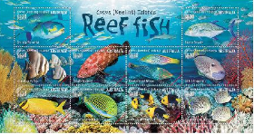
Some 2,750 kilometres north-west of Perth, the remote Cocos (Keeling) Islands is in the eastern Indian Ocean near the western edge of the Pacific. Its location at the interface of the Pacific and Indian Oceans as well as the expanse of ocean lying between Cocos and Indonesia are factors fundamental to the composition of its marine life; while the marine life of Cocos is composed of many fish species common to the Indo-West Pacific, it is also home to many species that do not otherwise occur in the Indian Ocean, and this results in a fish community characterised by some hybridisation. The Cocos Pygmy Angelfish is known only in the waters of Cocos (Keeling) Islands and Christmas Island.
Due to relatively little human-induced disturbance to the Cocos marine environment, its coral reef system is healthy and provides a good environment for the marine species it supports, which includes several hundred fish species. In 2022, the Australian government established the huge Cocos (Keeling) Islands Marine Park, a 467,054-square-kilometre conservation area, co-designed with the local community, that includes inshore coral reef and lagoon habitats, as well deep ocean environments.
This issue comprises 10 stamps, which together build an imagined subaquatic scene in the clear waters of this tropical territory. The photographs, taken by sometimes Cocos resident Karen Willshaw, represent a range of species belonging to nine fish families. Given the varying sizes of the fish, some artistic licence has been taken in showing them in a single scene.
$1.20 Greenlip Parrotfish Scarus viridifucatus (family Labridae) is also known as the Roundhead and Green-snout Parrotfish. It grows to around 32 centimetres in length.
$1.20 Bluefin Trevally With its electric-blue fins, Caranx melampygus (family Carangidae) grows to around 75 centimetres in length. It inhabits deeper lagoon and outer reef waters.
$1.20 Roundface Batfish Also known as the Longfin and Tall-fin Batfish, Platax teira (family Ephippidae) has two dark vertical bars across its body, a dark blotch below its pectoral fin and often a yellowish pelvic fin. It grows to around 40 centimetres.
$1.20 Tomato Rockcod Cephalopholis sonnerati (family Serranidae) is a striking grouper, coloured with a dense rich orange-red network of spots. It grows to around 57 centimetres.
$1.20 Checkerboard Wrasse The brightly coloured Halichoeres hortulanus (family Labridae) can grow to around 27 centimetres in length and inhabits sand patches in lagoons.
$1.20 Gilded Triggerfish The Gilded Triggerfish, Xanthichthys auromarginatus (family Balistidae), is also known as the Blue-throated Triggerfish. It grows to around 30 centimetres.
$1.20 Masked Rabbitfish Siganus puellus (family Siganidae) is also known as the Bluelined Rabbitfish for the network of uneven silvery-blue lines that cover its body; the dark line through its eye makes ‘masked’ an equally appropriate common name. It grows to around 38 centimetres in length.
$1.20 Bluelined Surgeonfish Growing to 38 centimetres, Acanthurus lineatus (family Acanthuridae) is well described by its common name, with blue and yellow lines running along its torso.
$1.20 Cocos Pygmy Angelfish Centropyge joculator (family Pomacanthidae) measures just 9 centimetres in length. This little yellow and deep-blue fish is the only species endemic to Cocos (Keeling) Islands and Christmas Island.
$1.20 Peppered Butterflyfish Also known as Gorgeous Gussy, Chaetodon guttatissimus is characterised by rows of small, irregular spots. This diminutive species grows to a length of around just 12 centimetres.
Australian Antarctic Territory (AAT) – Sidney Nolan’s Antarctica
Issue date: March 14, 2023
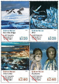
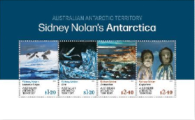
In January 1964, Sidney Nolan travelled with writer and fellow Australian Alan Moorehead to Antarctica, with a routine US Navy resupply operation. The pair visited the continent for eight days, during which time Nolan made around 200 watercolour sketches, which have since been lost, and photographed the deeply unfamiliar and awe-inspiring environment.
Returning to London, via New Zealand, the South Pacific and Australia, Nolan immediately set to work; the watercolour sketches and photographs, along with his memory, were the foundation for the paintings he made. Working at speed, he produced the Antarctica series of 68 paintings in oil on composition board between April and September that year, while also working on other paintings. The series comprises works depicting the landscape, explorers, scientists and more. The paintings represent not a passive white landscape, but one full of muscular forms, dynamic elements and intense and often-brooding colours. Shown in the UK, US and Australia between 1964 and 1967, the Antarctica series secured Nolan a significant measure of international critical acclaim.
$1.20 Volcanic Ridge April 1964, oil on composition board, 122 × 122 cm, private collection
Photo: courtesy Mornington Peninsula Regional Gallery
$1.20 Bird 14 September 1964, oil on composition board, 122 × 122 cm, private collection
Photo: courtesy Mornington Peninsula Regional Gallery
$2.40 Antarctica 27 August 1964, oil on composition board, 122 × 122 cm, Nathan & Camit Cher Collection
Photo: courtesy Mornington Peninsula Regional Gallery
$2.40 Explorers [20 September] 1964, 121.9 × 152.5 cm, oil on composition board, private collection, courtesy Pyms Gallery, London
Photo: courtesy Mornington Peninsula Regional Gallery
Australia – The Golden Age of Travel Posters
Issue date: March 7, 2023
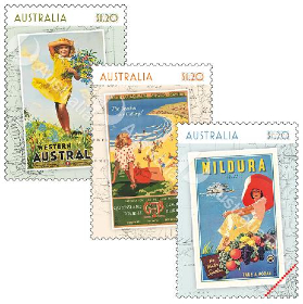
The 1930s were times of great hardship in Australia. The second half of the 1920s saw wheat and wool prices fall and greater competition for export markets. The Wall Street stock market crash in the United States, in 1929, had worldwide impacts, including in Australia. The national unemployment rate reached a staggering 32 per cent in 1932. Against this dire backdrop was a source of optimism, in the form of travel posters, produced largely during the 1930s (but also during the late 1920s and into the early 1940s), in what became known as the “golden age” of Australian poster design.
Travel posters commissioned by the newly-formed Australian National Travel Association (ANTA), the Victorian Railways, and other state-based tourism and railway boards, sought to promote tourism and recreation as both achievable and desirable – a series of simple joys. Commercial artists were tasked with encouraging Australians to “seek the winter sunshine”, to spend “lazy days” cruising the River Murray or to enjoy Queensland’s sunny beaches, with the added call to “see for yourself”, “go by train” and “take a Kodak”. Such posters were also produced to promote Australia as a sunny yet sophisticated travel destination for international travellers, including by the national airline, Qantas.
Three of the most popular and influential poster artists during this period, James Northfield (1887-1973), Percy Trompf (1902-1964) and Gert Sellheim (1901-1970), were colleagues at Melbourne’s Art Training Institute. While Sellheim’s designs were bold, graphic, minimalist and influenced by cubism, Trompf and Northfield, who were both born in small town Victoria, used “lush, painterly tones” and simplified realism to depict Australian landscapes, filled with happy holidaymakers enjoying the great Australian outdoors.
$1.20 Western Australia The Western Australia poster by Trompf highlights the region’s famous wildflowers – more than 10,000 species that create an incredible display during spring, defying the dry and infertile soils of the region. A smiling girl looks as though she’s about to walk right up and hand over a freshly picked bouquet.
The stamp image is © Percy Trompf Artistic Trust, courtesy Josef Lebovic Gallery, Sydney.
$1.20 South Queensland Surfing Resorts The poster by M Anderson (dates unknown) calls tourists to the beaches and resorts of sunny south Queensland, using a birds-eye perspective to show what fun people are having on the pristine, sandy shoreline below.
The stamp image is from the collections of the National Library of Australia.
$1.20 Mildura The Mildura poster by Northfield showcases the fresh produce and river cruises for which this region of Victoria is known, and it draws attention to the fact that its mild winters make visiting an attractive proposition for tourists located further south. The poster was produced by Victorian Railways as a way of competing with coach services, which were gaining in popularity by the 1930s.
The stamp image is © The James Northfield Heritage Art Trust and held in the collections of National Library of Australia.
Faroe Islands – Franking labels 2023: Villages
Issue date: February 20, 2023
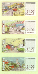
On Suðuroy’s east side, there is a 7-kilometre-long fjord, Trongisvágsfjørður. In this fjord, which stretches from southeast to northwest, we find the ancient settlements of Froðba, Tvøroyri, Trongisvágur, Øravíkslíð and Øravík, which today have more or less grown together into Suðuroy’s largest city, Tvøroyri municipality.
Froðba At the northeastern mouth of the fjord lies the old settlement Froðba with roots dating back to the Middle Ages. According to a local legend, Froðba must be the oldest settlement in the Faroe Islands. Its name refers to the legendary Danish king Frode, who founded a settlement there according to the legend – hence the name. This must be taken with a grain of salt – the name probably refers to one of the first settlers of the place and means something like Frode’s settlement or Frode’s land. Froðba is located in a very scenic area on the lowlands, a little inside the promontory Froðbiarnípa. Along the beach, we find ancient basalt columns bearing witness to violent volcanic activity dating back approx. Fifty million years ago when the Faroe Islands came into being.
The franking label motif shows one of Froðba’s old town districts, “uppi á Hamri,” where the well-known Faroese poet Poul F. Joensen lived.
Tvøroyri Somewhat paradoxically, Tvøroyri is the youngest settlement, located on the northern shore of the fjord, between Froðba and Trongisvágur. The area was once part of Froðba’s outskirts, but when the Royal Monopoly trade established a branch on the Tvøroyri isthmus in 1836, the settlement began to grow – especially after the abolition of the Monopoly trade in 1856. Private individuals took over the trading business, which over time expanded with increased shipping and fishing industry. At the turn of the last century, Tvøroyri had grown into one of the Faroe Islands’ largest towns with the largest fishing industry.
The franking label depicts the so-called “Kirkjubrekka” – the road up the hill to the church. The parish church was initially located in Froðba, but when the new settlement at Tvøroyri began to grow, it was decided to move the old church to Tvøroyri in 1856. From 1880 until the turn of the last century, the number of inhabitants in the parish doubled. It was therefore decided to build a new and larger church. The Danish architect Viggo Bertram designed the church – and emphasised that it should be able to withstand the harsh Faroese weather conditions, with intense storms and lots of rainfall. It left a unique mark on the church’s architecture; the solid half-timber work was bolted to a foundation of basalt stone, which had already been bolted to the rock foundation. It can be said that the church in Tvøroyri was built according to Matthew’s well-known parable about “building one’s house on a rock.”
The church was prefabricated in Norway – and in 1905, work began erecting the structure. Three years later, in 1908, the new beautiful church was ready for use.
Trongisvágur At the bottom of the fjord lies Trongisvágur, which like Froðba, is an old settlement that has grown together with Tvøroyri. From ancient times, Trongisvágur consisted of several districts along the river “Stórá,” which runs through the territory and meanders into the fjord. The stamp motif depicts one of these districts, “í Húsgarði.”
Over the past 40 years, Trongisvágur has undergone significant changes. A sports hall and later a football field were built at Stórá. There are a kindergarten, school and camping facilities on-site in addition to the usual expansions of buildings and infrastructure.
The beautiful natural surroundings include, among other things, an old pine grove with hiking trails – and along the west coast behind the settlement, magnificent geological formations of the oldest volcanic basalt layers are only visible on Suðuroy and the westernmost islands, Mykines and Vágar. Rangabotnur, with its coal seams formed in violent volcanic activity, lies southwest of the settlement. 50 million years ago. Coal was mined here almost a century ago – and from Rangabotnur towards Drelnes on the south side of the fjord, we can still see the woodwork remains in the cableway that brought coal down from the mines for further transport.
Hov In the fourth and last franking label, we leave Trongisvágsfjørður and go a little further south to the settlement “Hov” by Hovsfjørður. Hov is also an ancient settlement with roots in the Viking Age. The village is often mentioned in the Saga of the Faroese as the home of Havgrímur Illi, chief of the southern part of the Faroe Islands. “Hov” means temple/house of sacrifice, where people sacrificed and worshipped the Norse gods in the Viking Age. It is said about Havgrímur that he was “blótmaður mikil”, i.e. a man offering great gifts to the gods.
In the mountainside above Hov, along the old road to the north, we find impressive basalt columns from the volcanic activity which formed the Faroe Islands. West of the settlement lies the large waterfall Foldaráfossur in the river Hová. In the fjord near Hov, there is the small islet, “Hovshólmur” – and since the eighties, salmon have been farmed in the fjord. Down by the harbour facility is a small museum, art gallery and café in the old commercial building.
On the franking label, we see the church tower in the background. The church originally stood in Vágur but was moved to Hov in 1942 when Vágur erected a larger church in 1939.
Faroe Islands – The radar station at Sornfelli
Issue date: February 20, 2023
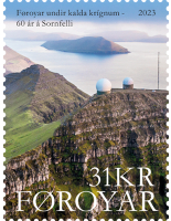
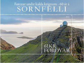
During World War II, the Faroe Islands were occupied by Great Britain. During the war, the British built a military airport at Sørvágur on Vágar, and several radar stations around the Islands, monitoring the waters and airspace around the Faroes.
60 years since the radar base at Sornfelli was taken into use The Faroese radar stations played an essential role in the Arctic supply convoys, mainly transporting American military equipment to the Soviet port cities of Murmansk and Arkhangelsk.
The British also set up a so-called Loran (Long Range Navigation) station in Vágur on Suðuroy to obtain more precise navigational data at sea and in the air.
After the war, Denmark regained sovereignty over the Faroe Islands and Greenland (Iceland had then completely seceded from the Danish kingdom in 1944). The USA showed interest in the LORAN station in the Faroe Islands and offered to overtake its operation. Denmark, however, having learned from the signing of unfavourable agreements regarding the American military presence in Greenland, rejected the offer and hastily decided to operate the station itself in 1946, even though they did not have qualified personnel for the task.
The Referendum of 1946 – Home Rule Act 1948 Denmark recognized that the separation during the war had changed the relationship between Denmark and the Faroe Islands. During the five-year British occupation, the desire for increased self-determination had grown in the islands. After the war, negotiations began for the Faroe Islands’ future position in the Danish kingdom and political authority. The talks dragged on without the parties’ having reached an agreement – and the Faroese were also divided among themselves. Therefore, Denmark formulated a home rule proposal, which was submitted to the Faroese Parliament. But even then, no agreement was reached. The consequence was that in 1946 the Faroese Parliament called a referendum on whether the Faroese wanted extended home rule or secession from Denmark. The referendum showed a slight majority in favour of secession among the votes cast – but was soon cancelled by the Danish government. Instead, in 1948, the Home Rule Act was introduced, with expanded powers for the Faroese parliament and national government.
When Denmark joined NATO in 1949, the Faroe Islands and Greenland automatically became members. It caused quite a bit of dissatisfaction in the Faroe Islands. But in response to a question from the Faroese member of parliament, Poul Niclassen, whether the Danish government had violated its obligation to submit the conclusion of intergovernmental agreements concerning the Faroe Islands to the Lagtinget – the Faroese parliament. Prime Minister Hans Hedtoft replied that it was a political treaty that fell outside the obligation to submit, specified in home rule legislation.
Denmark did not have the military resources to defend the North Atlantic parts of the kingdom effectively. The Faroe Islands and Greenland defence was therefore subordinated to SACLANT, NATO’s Atlantic Command in the USA. In the event of war, forces from Great Britain would carry out the direct defence of the Faroe Islands.
Faroe Islands Command In 1951, the Danish Navy established the Faroe Islands Marine District, later the Faroe Islands Command, to carry out sovereignty assertion, fisheries inspection, and rescue tasks in the Faroe Islands. The studies were carried out using ships that were already available – but in 1963, the navy got the new inspection ships of the Hvidbjørnen class, built especially for North Atlantic conditions and equipped with Alouette helicopters. At the same time, the new Marine station was constructed at “Hoyvíkstjørn” on the outskirts of Tórshavn and put into use in 1965.
NATO’s interest in the Faroe Islands was limited during the first years. NATO aircraft could use Vágar airport for emergency landings – and the large fjord, “Skálafjørður,” would become an anchorage point for NATO ships and submarines in case of war.
Loran C and the Polaris missiles However, during the fifties and with the technological advances of the Cold War, the strategic and tactical importance of the Faroe Islands changed due to their location in the middle of the North Atlantic, between the two main actors of the Cold War, the United States, and the Soviet Union. The power play of the superpowers unfolded on many levels – on land, the seas, and in the air. The increased military traffic required coordination and precise position fixing – and in the late fifties, the US Coast Guard installed 30 Loran C radio beacons all around the islands. One of these facilities was the Loran C station in Eiði on the northernmost part of Eysturoy, commissioned in 1960. The station was established with permission from the Danish government, paid for by the US Coast Guard, and operated by the Danish Lighthouse Service.
Loran C, Eiði, with its 190-meter-high transmitting mast, was a master station supported by slave stations around the North Atlantic. It improved navigation and position fix for NATO naval units. Among other things. For aircraft carriers, submarines, and military aircraft. In particular, the system was necessary for the first generation of submarine-based Polaris nuclear missiles, whose limited range meant that the subs had to operate in the Norwegian Sea for the missiles to reach their targets in the Soviet Union. However, Loran C’s military importance was quickly overtaken by technical developments. Improved navigational systems, satellite navigation, i.e., the military predecessor to today’s GPS navigation, were more accurate. In addition, the newer generations of the Polaris missiles had a doubled range, which meant that the Polaris submarines could operate from longer distances than the Norwegian Sea.
The radar station at Sornfelli In 1963, Faroese could ascertain that the mountain Sornfelli, which towers over the bottom of the Kaldbaksfjørður north of Tórshavn, had had its peak equipped with two strange-looking white domes. After three years of construction work, the radar station at Sornfelli, with the official designation, “NATO Early Warning Station Site 09,” was finally finished.
One dome was equipped with a large horizontal radar and the other with an equally sizeable vertical radar. Eighty meters down into the mountain itself, an operations bunker had been drilled out, with a shaft leading up to the two radars, which together provided the radar operators with a three-dimensional situational picture of the North Atlantic waters and airspace.
Further down the mountainside, in “Mjørkadalur” (Fog Valley) above “Kaldbaksbotnur,” an administration and residential building was built, completed in 1964. This was called Air Base Thorshavn and was attached to the Danish air force, which served the Sornfelli base installations. A part of the agreement with NATO was that the staff, radar operators, technicians, and service personnel had to be Danish, even though the radar station was a decidedly NATO project. For inscrutable reasons, the Danish government believed that this would make the presence of the radar base more palatable to the Faroese population.
Early Warning – but for whom? In the usual literature about the radar station at Sornfelli, it appears that it was an extension of the American-Canadian DEW (Distant Early Warning) chain, which was supposed to warn the United States of attacks by Soviet bombers. In an article in “International Politics – Scandinavian journal for international studies,” from September 2020, military analyst Esben Salling Larsen, from the Danish Defence Academy, points out, however, that this was not necessarily the case. Salling points out that in American sources about the DEW line, Sornfelli is not mentioned as part of the line. From 1961 to 65, the DEW line was extended with a constant presence of four warships with radar and four radar surveillance aircraft in the GIUK line, which ran from Greenland, over Iceland, to Scotland. But Sornfelli was, as I said, not a part of this extension.
Salling further demonstrates that, according to NATO sources, the radar station was built as part of NATO’s “Air Defence Ground Environment” (NADGE), a chain of airspace surveillance radars and control stations, which were established along NATO’s outer border with the Soviet Union, from Norway to Turkey. The purpose was to warn of tactical attacks against European NATO forces and territories. In this expansion of NATO’s warning network, the station at Sornfelli was one of the stations to be built first.At the same time, the Faroese airspace in the NATO context was taken over by NATO’s Supreme Commander in Europe (SACEUR), while the Supreme Commander in the Atlantic (SACLANT) continued the naval responsibility around the Faroe Islands. Therefore, the radar station in Sornfelli was part of Europe’s naval and air defence, which had to support anti-submarine warfare and the fight against the Soviet surface ships and air forces that protected the submarines. An eye had also to be kept out for a low-flying cruise and sea-target missiles that threatened NATO ships and aircraft – and after the radar station got a new three-dimensional radar in the 80’s and the ability to receive and forward radar images from NATO’s radar aircraft, you could register missiles that went below radar height. Thereby, the station became an essential part of electronic warfare – and, as part of the NADGE chain, could support high-priority tactical operations, according to Salling.
As a consequence of the apparent end of the Cold War in the 90s, the radar station at Sornfelli was closed in 2007.
However, there are plans to reopen it – but that’s another story.
Faroe Islands – Landscapes: Skálhøvdi
Issue date: February 20, 2023

Approximately midway on the east side of the island of Sandoy, one of the Faroe Islands’ most striking landmarks faces the tempestuous Atlantic Ocean.
This is the Skálhøvdi promontory, which separates the two villages, Skálavík to the north and Húsavík to the south. In the topographical sense, a ”promontory” is the term for a headland with its highest point jutting out into the sea. Ravages of time, erosion and repeated landslides have gradually eroded the seaside rock resulting in an indentation at the end, a so-called ”barmur” with vertical rock sides – thereby creating the distinctive headland that characterizes Skálhøvdi’s features.
In his book ”Søgur og søgubrot” (Stories and Fragments), Jóannes Dalsgaard tells us that Skálhøvdi was the last place on Sandoy where the old Faroese sheep breed existed before it was exterminated. Female sheep on Skálhøvdi used to have small upright horns – and the reason, according to the old shepherd, Pætur í Búð, was the fact that they were in part descendants of the old breed. Legend has it that a long time ago, ”big birds”, ie. guillemots, teals and razorbills bred in Skálhøvdi’s rock wall. But after a large landslide, the entire bird mountain crashed down on the Torvunøs indentation and the birds subsequently disappeared from the mountain.
The village of Skálavík, reportedly, had an original sandy beach just like Húsavík on the other side of Skálhøvdi. After a hurricane, possibly the infamous Candlemas hurricane in 1602, the sand disappeared and instead the beach became covered with pebbles. Someone puts this phenomenon in connection with the aforementioned landslide in Skálhøvdi, but that is improbable.
The pebbles have probably been there all along, just buried under the sand. And it probably takes some more time along with other conditions to shape the beautiful pebbles that make up the beach of Skálavík and Skálhøvdi. They were probably deposited back in the ice age, which incidentally shaped both Skálhøvdi and the valleys where Skálavík and Húsavík are located.
Even though the big birds disappeared from the mountain in Skálhøvdi, men from Skálavík could still hunt the smaller puffin, south of Borðtangi. A hole had been made through the seaweed, so that at low tide you could walk barefoot from the beach under the indentation, over to a place on the south side, wherefrom puffins were caught with ”fleygingarstong” – a racket-like rod with a net at the end.
In the sea just off the promontory, there is also a skerry, popularly called Flidnasker, because it was populated with common limpet (patella vulgata), ”fliða” in Faroese. There they used to pick up the limpets that were used for bait in coastal fishing.
Skálhøvdi is the landmark of the village of Skálavík. An impressive phenomenon of nature and geology, whose dimensions are best viewed from a boat at sea. Such a visit is most definitely recommended if you are lucky enough to be in the area.
Faroe Islands – Art by Arnold Vegghamar
Issue date: February 20, 2023

The sharp blue and green formations of mountains and grass quiver in the yellow and red rays from the setting sun.
It is a magnificent natural experience which is displayed with full force and dramatic splendour of colours in the painting Twilight from 1993. The master behind this work, Arnold Vegghamar, is his own man both stylistically and motivically to such an extent that the viewer in front of one of his works is rarely in doubt as to the author‘s identity. The recognizable style is achieved because the visual artist endows a classic Faroese landscape painting with a distinct perspective, in many cases by going very close to the subject, just as he uses atypical effulgent range of colors.
The painter Arnold Vegghamar was born in 1937 in Viðareiði. He is an autodidactic painter who already the fifties started working as as visual artist, participating in the Ólavsøka Art Exhibition in 1957. He was then a student at the short-lived but important art school run by the modernist pioneers, Ingálvur av Reyni, Jack Kampmann and Janus Kamban in the winter of 1958-59. Vegghamar was apprenticed to a goldsmith and worked in the trade for a number of years, whilst also painting, but for the last several years he has devoted himself entirely to visual arts in the studio at his home in Viðareiði.
In 2010, the Faroe Islands Art Museum held a large separate exhibition displaying Arnold Vegghamar’s older and more recent works. Here we see an encapsulation of Vegghamar’s distinct artistic development towards an increasingly radical simplification and abstraction of landscape motifs, which unmistakably took off at the start of the new millennium. These images appear almost primitive in their intrepid construction and colour choices, with few but strong colours and a powerful, simplified field painting. During his many years in the service of art, Arnold Vegghamar has developed his composition from naturalistic landscape painting and a fierce coloristic expressionism to a relatively simple and unostentatious style, in which he reinterprets the well-known theme of the village by the sea inspired by his own surroundings in and around Viðareiði. He has reiterated and simplified this motif, so that it has become iconic in paintings that adorn the walls of many homes.
As evidenced by a painting like Bygd (Village) from 2007, the motif is expressed in naivistic style with houses devoid of doors, windows or other realistic details. The red, yellow and black cabins are almost arbitrarily placed on the painting’s surface like floating Lego bricks above a green ground representing grass. In addition, we observe ocean, sky and mountains. These bricks form some of Arnold Vegghamar’s basic elements, which he arranges diversely in a seemingly endless series of combinations.
Despite the cheerful, luminous colours in Arnold Vegghamar’s paintings, the impression can come across as serious and mystical – the landscape paintings are usually empty of people, revealing only life provided by nature. On the other hand, the candy-coloured rocks in the mountains and by the beach seem vibrantly alive, almost as if they were populated by supernatural beings. This gives Vegghamar’s pictorial world a coherent character, which is further emphasized by the horizontal line and the edge of the mountain that meanders through the visionary landscape portrayals.